

Photos courtesy of Mike Hermann and Justine Andronici.
Headed out to a state park this summer for a little adventure?
Sure, you could whip out your cell phone and hit the Google maps app for a potential route—but, how boring.
Alternatively, you could go old school with a physical Purple Lizard map, which is crawling with ideas on everything from a hiking or biking trail to a boat launch ramp to a picnic or campsite area.
Ten different regional Pennsylvania maps and a newly released map of the entire state illustrate the vast nature that makes up Pennsylvania, highlighting the recreational aspects of the land. As State College-based Purple Lizard declares on its smooth-coated, waterproof paper maps: “Your backyard just got a whole lot bigger.”
When traversing the wilds of Pennsylvania, cell signals might disappear, but the Purple Lizard will continue to guide, highlighting features that online maps never imagined. Even downloaded trail maps might not point out details like where boaters must take boats out on creeks or where a wildlife sanctuary is located or how different trails connect.
“Our maps are going to show you things like waterfalls, covered bridges, vistas, cultural features and history, as well as roads and trails,” cartographer Mike Hermann said. “People can discover all these things they never knew were there.”
On his maps, Hermann, who founded Purple Lizard in 1997, features not only obscure land details unlikely to show up on GPS maps, but fun facts and sites. His Pennsylvania map includes 124 state parks, 20 state forests, 114 rail trails and bikeways, 53 mountain bike destinations, 30 long-distance hiking trails, 20 ski areas and 17 water trails and whitewater destinations.
“It’s hard to beat opening up a big map and seeing all of the options in a way you can never see on a phone or a tablet,” Hermann said. “They’re really about taking the most interesting route, where GPS and apps are about taking the fastest route.”
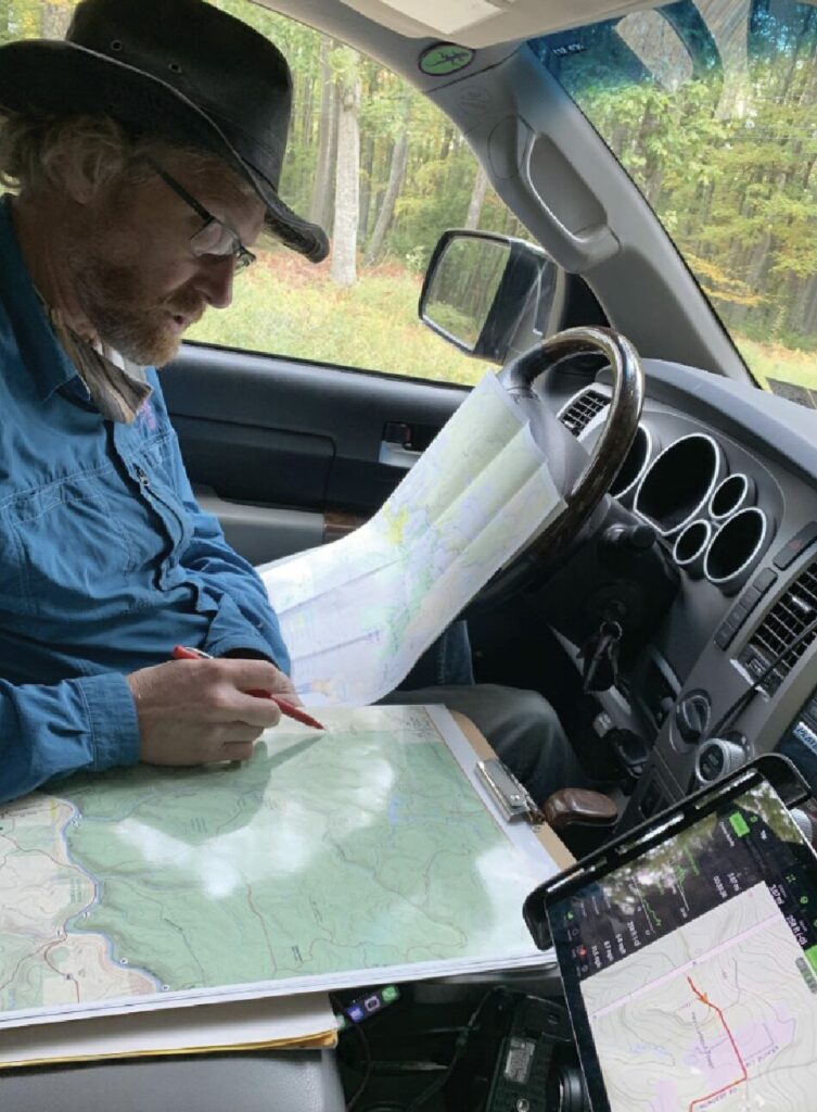
Mike Hermann
Highly Curated
A professional mapmaker for 30 years, Hermann and his wife Justine Andronici have worked to turn Purple Lizard into the preeminent recreational mapmaker in the Mid-Atlantic region.
The team of four usually juggles two or three maps at a time with their catalog of up to 18 maps, most of which are updated every two or three years. They spend lots of time on the road, visiting sites, meeting with land managers, driving roads, and noting trail intersections, trail heads and shared use trails.
In addition to the 10 regional Pennsylvania maps and the state map, Purple Lizard has two maps in West Virginia, two in Virginia and one in Ohio. They also have one for Scotia Gamelands in the State College area and one for Rincon, Puerto Rico, which pinpoints the surf spots and beach access where Hermann and Andronici vacation. Next up is their first map of western Maryland, one of Wayne National Forest in Ohio, and expanding the line of maps in West Virginia and the Pennsylvania Wilds.
“Our maps are highly curated specifically for outdoors enthusiasts,” Hermann said. “They focus on everything you need to plan your adventure.”
They do this by meeting with land managers, state forest and state park managers, national forest managers, county managers, local tourism agencies, local hiking and bicycling clubs, outdoors retailers and more.
Jeff Wood, owner of the Whistlestop Bookshop in Carlisle, loves displaying Purple Lizard maps and working with their team. He said that map buyers are equally split between locals in the tri-county area and tourists, and he also sells them on his website to people from all over the United States.
“The maps are special because of the quality of research that goes into them, the accessibility of all the information in one handy place, the excellent packaging, and the reasonable price,” Wood said.
Bruce Hollern’s personal experience with Purple Lizard maps echoes that. Hollern, the Pennsylvania Environmental Council’s vice president for Western PA, said that he was recently in a Trader Joe’s in State College when a woman came up to him asking him about the best places to go outdoors.
“I said, ‘What you should do is go buy a Purple Lizard map,’” he said. “So many people rely on digital platforms to help guide them, but these maps are a tactile way and so visually stunning to look at and learn to understand topographies of very distinct areas.”
Purple Lizard and the PEC have a close working relationship, which includes promoting land stewardship, sharing information and offering feedback on trail projects.
For those not interested in paper maps, Purple Lizard maps are available in digital form on the Avenza platform. Whatever format one chooses, Purple Lizard includes nearly every land detail and invites treasure hunts, as well. Wherever a Purple Lizard logo appears on a map, a surprise like a waterfall or a vista awaits.
“Everybody thought the paper map was dead, the same way they forecast the printed book would be dead,” Hermann said. “That hasn’t really been the case. Though I don’t know if we’re quite as hip as the resurrection of vinyl records.”
Purple Lizard maps are available in bookstores and outdoors stores across the state as well as at www.purplelizard.com. To learn more about the PEC/Purple Lizard partnership, visit www.pecpa.org/news/explore-pa-with-pec-and-purple-lizard-maps.
If you like what we do, please support our work. Become a Friend of TheBurg!